Navigation project summary
It's not always possible to stick to plans, but despite my atavistic Latin fatalism, up to now I've really done the best I could; now I can only expect help from the Gods. ;)
@1500 nm traveled a brief summary of the navigation plan.
Start Legs
Having sailed the entire cold and foggy Adriatic (480nm), we entered the Ionian, warmer but still difficult. The north winds are always particularly violent with very steep and fast seas. The 260nm traveled are worth double. Average wind F6.

The sweetness of Sicily and its climate refreshed us for the second leg, from Siracusa to Carloforte (Sardinia) via Trapani.

In Carloforte technical stop waiting for the Mistral arriving between Thursday 1st and Friday 2nd February.
We decide to leave on Friday morning hoping to catch the tail of the wind and stay in the flow until the Balearic Islands.
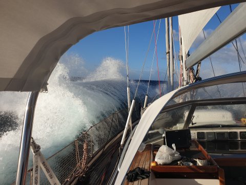
But as almost always happens, the wind goes and the wave stays. Result: max wind 12kts but ocean model wave: period over 15 seconds and average height 3.5m. Never seen in Med.
Not very comfortable navigation for 3 nights and 3 days up to 30 miles from Ibiza where everything calms down and you can rest.

Time to wake up the petrol station attendant on Sunday morning to get some diesel and set off again towards Almerimar where I would like to have our rigging checked after over 1500 miles travelled.
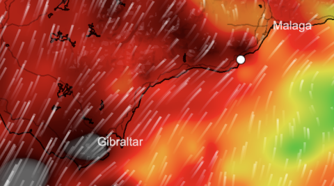
We will then continue to Gibraltar where I find my women; Anna and Emma who will come to greet us before entering the Atlantic.

Main Legs
Then the Canary Islands with landing in Lanzarote where we will stop for a few days to repair the support of the flat block of the base on the deckhouse. Then Capo Verde to the islands of Sao Pedro and Santo Antao for a healthy visit before jumping towards the South Atlantic Ocean on the remote Brazilian island of Fernando de Noronha and then Recife in Brazil.
We will continue along the Brazilian coast to discover (by the sea) Salvador, Porto Seguro, Cabo Frio, Rio de Janeiro, Angra dos Reis.
Then the southern Brazilian states up to Punta de l'Este in Uruguay where Pius will remain to rest until the Austral summer (November 2024).
Final Legs (from November 2024)
Uruguay, Argentina (Ushuaia), ascent to the Cape de Espiritu Santo in Chile to enter the mythical Strait that Fernão de Magalhães discovered in 1520.


Then the Pacific Ocean...
2 Comments
Tegolina
Ciao, leggendovi sembra che la navigazione prosegua senza troppi intoppi. Volevo prendere info sulle prossime condizioni meteo, ma devo focalizzare meglio l’attenzione sulla rotta 😅 Curiosità: Le Condizioni meteo marine rispettano quelle della costa più vicina o si differenziano di molto? Vi auguro buona navigazione nell’attesa del prossima pagina del Diario di viaggio. Un saluto a presto la Lo.
AL
Ciao LO. Grazie per il tuo messaggio! Si per ora solo qualche piccolo problema tecnico che speriamo di risolvere a Gibilterra prima del salto in Oceano. Il Meteo per noi è importante controllarlo nella zona di navigazione che affrontiamo considerando micro aree di 200 miglia al giorno max. Ci colleghiamo non appena emettono il nuovo aggiornamento, di solito alle 8h30 e 20h30. I siti meteo terrestri sono leggermente diversi. Questo https://www.predictwind.com/it/apps/offshore-app è uno di quelli che usiamo con possibilità di confrontare 4 o 5 modelli diversi. Il migliore è quello Europeo ECMWF. Arrivati ora martedi 6 Feb ore 01h00 ad Almerimar partiti da Carloforte Ven 2 Febbraio . Buona notte. AL.